Route: Figure Eight Loop (French River Provincial Park)
Distance: 40km
Time: Day 1 (15.3km) Day 2 (7.1km) Day 3 (13.3km) Day 4 (4.6km)
Canoe: 16'6" Kevlar Prospector
Map: http://goo.gl/maps/gKZY6
 |
| Figure Eight Loop - French River Provincial Park |
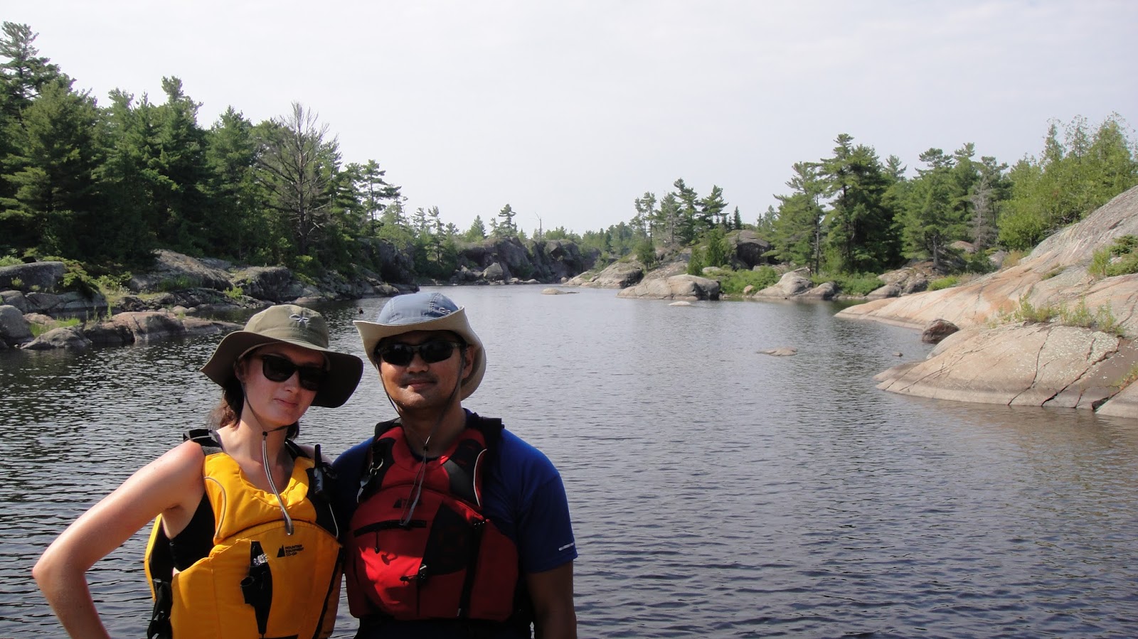
Liz and I were pumped for our first
camping trip of the season, and especially excited to visit a new park and a
new region of Ontario. Our route was to follow the Figure Eight Loop as
described by Kevin Callan in his book A Paddlers Guide to: Killarney and the
French River. The A Paddlers Guide to: series of books are a great source of information on routes and planning tips to many different regions and parks in Ontario.
Day 1
Day 1 started at 4.30AM. We woke
up, showered, packed up food and gear, headed over to the Harbour Front Canoe
and Kayak Center to pick up LF7, scooted over to Gill&Rems, loaded the van
and hit the road. Driving to the French River Provincial Park took about
3 hours, with a quick breakfast break at McD's in Parry Sound and a short side
detour to the park’s brand new visitor’s center. We arrived at the
Hartley Bay Marina at around 11.30AM. From their offices, we were issued park
permits, arranged a canoe rental for Gill&Rems and obtained overnight
parking for the partay-van.
A quick unloading of the van and
transfer of our packs to the canoes and we were on the water within half an
hour.
 |
| Everyone is gung-ho...azn stylz ding! |
 |
| First strokes along the French River |
Our original plan for Day 1 was to
paddle out of Hartley Bay, through Wanapitei Bay, turn east after Canal Island,
paddle south down the Eastern Outlet, find the Whale’s Mouth and turn west
again to link up with the Main Outlet.
From there, take the Main Outlet to Dallas Rapids and out to the
Northeast Passage and on to Georgian Bay. I estimated a light three hour paddle or so. Turned out I was way off in my estimation of what we could
achieve on the first day.
The first problem we encountered almost
immediately after setting out was navigating the French River. The area
is dotted with loads of small islands and little passageways that can completely confuse your orientation. Gill and Liz were our dedicated navigators for the trip, and both did a formidable job, but tracking
our location on park map and the numerous "rafting" of our canoes to
converse about our location slowed us down.
Two hours in and not having been able
to locate a single campsite in order to irrefutably confirm our location in the
park, it was time for some lunch. Good call Gill. Lost, hot,
hungry, and thirsty...time for a break.
 |
| Liz...where are we? |
Scoops of orzo salad made by
Gill&Rems, a few gulps of water, reapplication of sunscreen and a long
discussion on our location and we were good to go. But not before
admiring a view of the beautiful area.
 |
| There is a cottage on that island...so nice! |
 |
| Take a load off and have some lunch |
After getting us on the right track,
the ladies directed us past Canal Island and towards our first campsite (#628)
which was occupied by an elderly couple who confirmed the site number.
This is where we discovered potential problem number two: locating
campsites. What we discovered from our first located campsite was that
the markers for sites were 5"x5" faded orange squares placed on trees
set back from the water's edge and often hidden by the foliage of other trees and
plants. Unless you were right at the campsite, it was unlikely that a
paddler would be able to spot a campsite marker. Here is an example. This
is our campsite from the water on Day 2. Can you spot the marker?
 |
| Rems eagle-eyed this site, and pretty much every site we ever found on the trip |
Paddling west for another kilometer we
found campsite #629 and made a turn south onto the Eastern Outlet and into
strong head-wind. Unanticipated problem number three: head-winds.
Probably because the wind was coming off of Georgian Bay and straight up the
main channels of the park, most of our day was spent paddling into a head-wind,
none stronger than what we encountered on the Eastern Outlet. Expecting a
quick 45 minute paddle to the Whale's Mouth turned into a tiring 1h30m paddle
through choppy water. A little worried by our navigation skills, and
nervous about finding the Whale's Mouth (a small passageway linking the Eastern
and Main Outlets), we were relieved to find a grouping of cottages that
signified the location passageway.
 |
| Ta-da! The Whale's Mouth. Keep this picture for future reference |
 |
| Gill&Rems paddling through Moby Dick |
Getting tired and losing the day, our
ambitions to reach Dallas Rapids and Georgian Bay were fading.
Recognizing our depleting energy levels, Liz tabled the idea of altering our
Day 1 goals and start looking for a campsite around The Elbow (the main
junction between the Main Outlet and the Eastern Outlet). We all agreed to
this plan and started looking for a campsite in the area. Approaching The
Elbow, we could see that the two closest campsites were occupied. What we also saw coming down the Main Outlet was
another group of paddlers looking for a campsite for the night. Amazing
race time! Good thing we already formed an alliance with
Gill&Rems.
It was 7Fast7Furious to find the next
two campsites before the second group of paddlers did. Paddling on, Liz
and I bombed through The Elbow in search of the next closest site.
Thinking we had found it, we docked our canoe and Liz jumped on shore to check
out the area only to realize we were in the wrong place. Behind us we
watched the second group paddle by and soon after Gill&Rems. Liz and
I were sure we had lost out on the next campsite. Disappointed, Liz jumped
back into LF7 and we resumed our paddle behind Gill&Rems, losing valuable
time and not knowing where we would find a campsite for the night.
However, to our surprise, the second
group made an unexpected stop on shore to review their map and orientation.
As confused as we were earlier in the day,
we were able to gain a short 5 minute lead on this group. It was all up
to Remil and his eagle-eyes to spot the next two campsites.
The next site was occupied by two old
ladies. Briefly chatting with them, they mentioned they had seen no other
paddlers all day long, until the last hour when four groups had gone by.
Nice. Paddling on in search of the last campsite before
the Dallas Rapids portage, we had the second group drafting in our
wake trying to catch up to us. Coming around a bend in the river, Liz and I were
relieved to see Gill&Rems docking their boat on a large beach area.
Success! Gill&Rems had found the last site and we had a place to stay
for the night. Liz and I quickly docked next to Gill&Rems' boat and
were thankful to rest. We never did see the second group of paddlers
again, and they most likely perished on the open water, driven mad by the maze
of islands and channels.
 |
| Not a bad sunset for Day 1 |
Glad to stop for the day, we realised
some failings at our campsite. Murky algae water, a swamp area
next to the site, random poops scattered around (probably from a dog at the
campsite previously), a weird stank (probably from the poops) and no box at the
crapper. Just a hole. Never settling, Remil and I paddled on to the
Dallas Rapids portage to look at one more potential campsite. It was
worse, so it was time to deal with what he had and get our squat on.
First night camping tradition called
for too much steak on the BBQ...so not to disappoint:
 |
| Steak it up |
 |
| Time to relax |
Our first day on the French River
turned out to be much harder than I anticipated. Strenuous paddling,
frustrating navigation and an unremarkable campsite left me dejected and
unmotivated. Running on only a few hours of sleep did not help
either. Tomorrow was a new day, but for now, the French River had failed
to impress and I was not excited about three more days paddling the French
River.
Day 2
Our revised goal for Day 2 was to
make it to mouth of the Eastern Outlet where five campsites were located, if
they could be found. We had about half the distance to paddle this day,
so we were aiming for a shorter day on the water and a longer day enjoying a
more remote campsite.
 | |
| Packed up and ready to go |
Our first obstacle of the day was a
short 180m portage around the Dallas Rapids. Approaching the portage we
saw the remnants of old logging machinery that was used to move timber down the
French River. Looked to me like the remains of the Iron Giant.
 |
| Maybe the Iron Giants shoulder? |
It was tough to get a good look at the
Dallas Rapids and see whether they were runnable, but not taking any chances,
we used the portage to get around them. After completing the portage, it was
a straightforward paddle down the Main Outlet to its mouth at Georgian Bay
where we would hang east and search among the campsites for a place to stay
overnight. Although we were still paddling into a head-wind, this day
allowed us to take in more of our surroundings. The Main Outlet’s rocky
banks were beautiful. We passed numerous private cottages and saw an old
church originally built for the families of the French River’s logging
settlement.
 |
| View from Dallas Rapids looking back at where we set up camp on Day 1 |
Passing another canoe and confirming
our location near Bluff Point, we quickly located a couple of campsites.
Both had their failings: an island site only had space to set up one tent, and
the site at Bluff’s Point was also quite small and unremarkable except for its
views of the Northwest Passage. Time to keep shopping. We checked
out one more island site which was too rocky to stay on, and debated whether it
was worth paddling onwards or settling for a campsite we had already
found. “Keep going!” was the group’s decision, and straight into round
two of our French River navigational nightmare.
 |
| Lookout on Bluff Point's campsite...windy |
 |
| Island site across the water...had potential..but a fail |
The area we were paddling into had numerous
little islands and when paddling in the midst of them, it was extremely
difficult to tell which one we were next to on our map. After a long
rafting session, the group picked a direction we thought would take us to the
next campsite. However, after rounding the next island we felt lost
again. Noticing a tiny rock passageway, the width of my outspread arms, I
suggested we paddle through and see what was on the other side. I vaguely
remembered a similar passageway on a Youtube video, but mostly thought it would
be fun to go through such a narrow spot. Too shallow to paddle through,
Liz and I used our hands on the rock face to pull ourselves through the
passageway.
 |
| Squeeeeeeze |
Once through the passageway, we resumed
our search for the next campsite. It was
not too long when Liz and I heard comforting words from our alliance teammates
behind us, “There’s a site!” Eagle-eye-Remil had pulled through
again. It was a good looking site, but was
it the best site? There was one more campsite close by and never ready to
settle, we decided to check it out before making a final decision on where to
stay the night. After a short search through a further maze of islands we found
the final campsite are were rewarded with a 5-star resort. Flat
rocks to sit on and sun, clear water to swim in, two level areas to set up our
tents, a nice fire pit with a grassy area to walk around, a table to prepare
food on and even a poop-box. This was the high life, no squatting tonight
(unless preferred)! This site was “the one” and there was no way we were
moving.
 |
| A literal oasis |
 |
| Beautiful rock outcroppings around the site to explore |
 |
| Tree-hammock...pretty convenient |
We settled in for the day at the
campsite, got a fire started and made lunch (tuna melts). Afterwards it
was some swimming and reading and soon it was time for dinner (burritos).
A wonderful sunset, full bellies and a nice camp fire burning was an amazing
end to the day.
 |
| After-dinner dip |
 |
| Sunset over our campsite |
 |
| Entity |
But there was one more unexpected
visitor that evening. As the sun dipped below the horizon, a friendly
buzzing started around us. And as the
twilight became more faint, the buzzing turned from friendly to frenzy.
Mosquitoes. Swarms of them emerged and began attacking everyone No exposed
skin was spared. Even covered body parts were not saved as my elbow
suffered over 40 bites through my long-sleeved shirt. Impossible to enjoy
the fire, we made a frantic dash to our tents. That was the end Day 2 for
all of us, but I think we all had a great time exploring and experiencing the French
River.
 |
| Rems fully prepared for Pitch Black 2 |
Day 3
Day 3's plan was to paddle as much as
we could back to Hartley Bay and find a campsite close by in order to make our
final day’s paddle back to the marina easier. We had one portage to find
and a long-ish paddle back up the Main Outlet, but we were finally going to
have the wind at our backs.
Using directions from canoeists we met
on the water the day before, we were quickly on route to the portage. The
passageway through the rocky banks of the Eastern Outlet towards the portage
was probably some of the most delightful scenery I had seen on the whole trip.
 |
| Paddling our way back |
 |
| Easy does it through the shallow river |
Both easy to find, and easy to cross,
the portage turned out to be cinch. Originally created as a route for
loggers traveling through to Georgian Bay, the portage was a 250m wooden
walkway.
 |
| Gill&Rems Camping...matchy matchy |
 |
| JizFree posing...who has more beard, J or R? |
 |
| Hazah! |
 |
| Packed up on the other side |
 |
| Easiest portage evah! |
After the portage, it was quick paddle
across the serene Bass Lake and up towards The Elbow. After another hour of
paddling we were at Canal Island; so much easier to recognize having passed by
two days before. From here, it was up into Wanapitei Bay where were
decided to search for a campsite for the night. After checking out
several disappointing campsites, we settled on a large site set high up on the
rocks. We were now on a much higher traffic area of the river and while
the views were still nice, there were private cottages in sight and regular
boat traffic along our waterfront.
 |
| French River from the rocks at our campsite |
After some swimming, reading and making
wood (my favorite) we made dinner (couscous with tuna) and set ourselves up to
play some cards on the rocks overlooking the river until sundown. As sundown passed and the light disappeared
our mosquito friends come out to join the party. We were prepared this night and after quickly
packing up our gear , we were back in our tents. And great timing too…within five minutes of zipping
closed our fly, the rain started in for the evening.
Day
4
The rain of the previous evening had not completely disappeared,
and Day 4 started with grey skies. After
a quick breakfast, we broke down camp, loaded the canoes and we were on the
water paddling towards home. We were
only about an hour and half away from the marina and we took a leisurely pace
getting back. We passed some amazing
cottages built on the French River, including one cottage that had its own
canon for defense.
 |
| Last time we pack up of our gear |
Overall, paddling the French River over four days was a fun
and exhilarating experience. One route
alternation I would make is to skip the Eastern Outlet, and gun for The Elbow
or Dallas Rapids portage on the first day. For another trip, I think exploring the islands in the
Northeast Passage or paddling and camping in Fox Bay would be a fun addition.
No comments:
Post a Comment